AMR: Autonome Navigation mit einem JetBot ROS AI Roboter: Unterschied zwischen den Versionen
Keine Bearbeitungszusammenfassung |
Keine Bearbeitungszusammenfassung |
||
| Zeile 63: | Zeile 63: | ||
* ROS2: Humble Hawksbill | * ROS2: Humble Hawksbill | ||
* Webots: R2023b | * Webots: R2023b | ||
* Gazebo: 11.10.2 | |||
* Rviz2: 11.2.8-1 | |||
== Summary == | |||
This project aims to implement autonomous navigation capabilities in a JetBot robotic platform using ROS2 (Robot Operating System). The JetBot will be equipped with a Lidar sensor to perceive its surroundings, allowing it to generate detailed maps using SLAM (Simultaneous Localization and Mapping) techniques. Additionally, the robot will utilize odometry data to refine its positional awareness within the mapped environment. | |||
'''The core objectives of the project include: | |||
''' | |||
'''Lidar-Based Mapping:''' Integration of a Lidar sensor for real-time environmental sensing, enabling the JetBot to generate accurate and up-to-date maps of its surroundings. | |||
'''SLAM Implementation:''' Employing SLAM algorithms to simultaneously map the environment and localize the JetBot within it, ensuring adaptability to unknown or dynamic spaces. | |||
'''Odometry for Localization:''' Utilizing odometry data to enhance the robot's localization accuracy, particularly in scenarios where Lidar data may be limited or noisy. | |||
'''ROS Integration:''' Implementing and optimizing these functionalities within the ROS framework, leveraging its extensive libraries and tools for seamless communication and coordination between different components. | |||
'''Autonomous Guidance:''' Developing algorithms and control systems that enable the JetBot to autonomously navigate through indoor environments, avoiding obstacles and optimizing its path based on the mapped environment. | |||
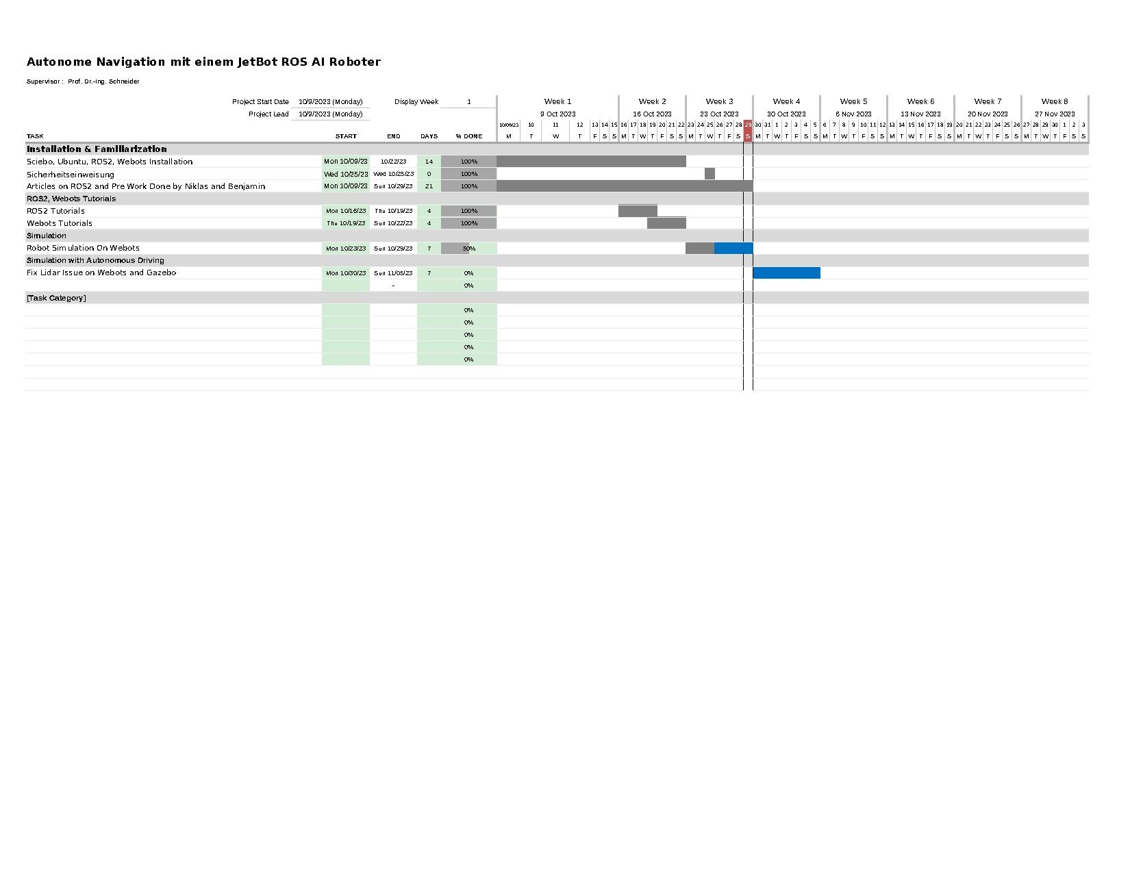
== Project Plan == | == Project Plan == | ||
Version vom 13. November 2023, 01:03 Uhr

| Autor: | Neaz Mahmud |
| Art: | Projektarbeit |
| Modul: | Project Work (ELE-B-2-7.02) |
| Dauer: | 09.10.2023 - xx.yy.2024 |
| Arbeitszeit: | TBD |
| Betreuer: | Prof. Dr.-Ing. Schneider |
| Prüfungsform: | Modulabschlussprüfung als Hausarbeit (Praxisbericht, Umfang 10-50 Seiten) und mündliche Prüfungsleistung (Präsentation, 15 Minuten) |
| Mitarbeiter: | Marc Ebmeyer, Tel. 847 |
Einführung
Seit über 2 Jahren arbeiten wir mit der Arbeitsgruppe Robotik und autonome Systeme an der autonomen Navigation eines Fahrerlosen Transportfahrzeugs (FTF, s. Abb. 1) mit der Firma Hanning zusammen. Für die Weiterentwicklung benötigen wir studentische Hilfe.
Aufgabenstellung
- Einarbeitung in das bestehende System
- Überprüfung und Verbesserung der bestehenden Dokumentation
- Ansteuerung des FTS
- Geregelte autonome Indoor Navigation des FTF
- Vermessung und Bewertung der Güte der Fahrt mit dem bestehenden Referenzsystem.
- Test und wiss. Dokumentation im HSHL-Wiki
Anforderungen
Das Projekt erfordert Vorwissen in den nachfolgenden Themengebieten. Sollten Sie die Anforderungen nicht erfüllen müssen Sie sich diese Kenntnisse anhand im Rahmen der Arbeit anhand von Literatur/Online-Kursen selbst aneignen.
- Umgang mit Linux
- C-Programmierung
- Dokumentenversionierung mit SVN
- Optional: Simulation mit WeBots
- Optional: Umgang mit ROS2
- Optional: Partikel Filter SLAM
Anforderungen an die wissenschaftliche Arbeit
- Wissenschaftliche Vorgehensweise (Projektplan, etc.), nützlicher Artikel: Gantt Diagramm erstellen
- Wöchentlicher Fortschrittsberichte (informativ), aktualisieren Sie das Besprechungsprotokoll - Live Gespräch mit Prof. Schneider
- Projektvorstellung im Wiki
- Tägliche Sicherung der Arbeitsergebnisse in SVN
- Tägliche Dokumentation der geleisteten Arbeitsstunden
- Studentische Arbeiten bei Prof. Schneider
- Anforderungen an eine wissenschaftlich Arbeit
Getting Started
- Praxissemester von N. Heiber
- Projektarbeit von B. Dilly
- Lesen Sie die ROS2-Tutorials
- Installation von Linux und ROS2 [1]
Softwarestand
Verwenden Sie ausschließlich diese Software:
- Ubuntu: 22.04.3 LTS
- ROS2: Humble Hawksbill
- Webots: R2023b
- Gazebo: 11.10.2
- Rviz2: 11.2.8-1
Summary
This project aims to implement autonomous navigation capabilities in a JetBot robotic platform using ROS2 (Robot Operating System). The JetBot will be equipped with a Lidar sensor to perceive its surroundings, allowing it to generate detailed maps using SLAM (Simultaneous Localization and Mapping) techniques. Additionally, the robot will utilize odometry data to refine its positional awareness within the mapped environment.
The core objectives of the project include:
Lidar-Based Mapping: Integration of a Lidar sensor for real-time environmental sensing, enabling the JetBot to generate accurate and up-to-date maps of its surroundings.
SLAM Implementation: Employing SLAM algorithms to simultaneously map the environment and localize the JetBot within it, ensuring adaptability to unknown or dynamic spaces.
Odometry for Localization: Utilizing odometry data to enhance the robot's localization accuracy, particularly in scenarios where Lidar data may be limited or noisy.
ROS Integration: Implementing and optimizing these functionalities within the ROS framework, leveraging its extensive libraries and tools for seamless communication and coordination between different components.
Autonomous Guidance: Developing algorithms and control systems that enable the JetBot to autonomously navigate through indoor environments, avoiding obstacles and optimizing its path based on the mapped environment.
Project Plan
==
→ zurück zum Hauptartikel: Studentische Arbeiten